Satellite Imagery & Virtual Constellation Remote Sensing Services
 Visiona Tecnologia Espacial
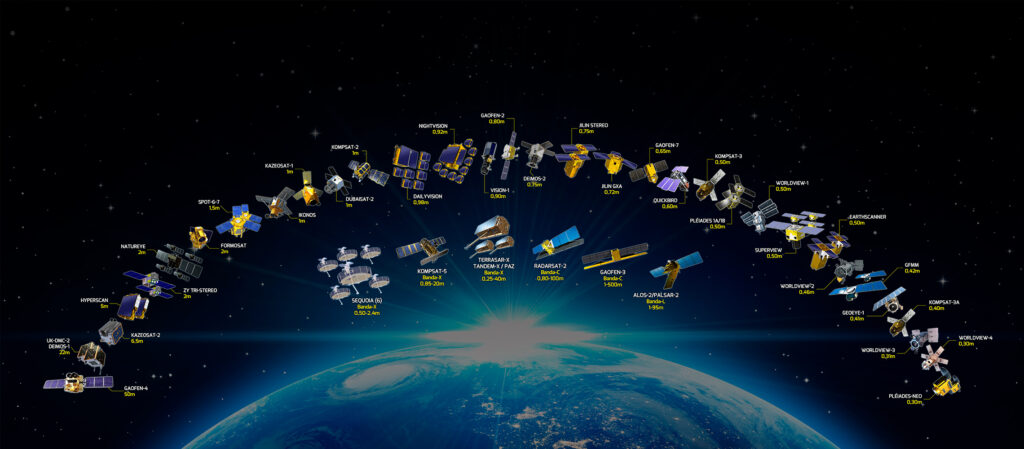
Official Brazilian distributor for major Earth-observation satellite operators, giving customers access to a 75+ sensor virtual constellation for optical and radar imagery.
Technical specifications
- Virtual constellation size
- 75+ Earth-observation sensors
- Optical resolution
- Up to 30 cm
- Radar resolution
- Up to 25 cm
- Radar bands
- X, C and L band (L-band: only orbital platform of this type in the world, per Visiona)
- Distribution role
- Official Brazilian distributor for leading global satellite imagery operators
About
As a space-systems integrator, Visiona is the official distributor in Brazil for several of the world’s leading Earth-observation satellite operators, giving customers access to a virtual constellation of more than 75 remote-sensing sensors plus digital elevation models at multiple precision levels. Operating as a multi-platform orbital remote-sensing operator, Visiona can select the sensor best suited to a given mission and deliver high revisit rates and large imagery volumes. The portfolio spans optical imagery at spatial resolutions down to 30 cm and radar imagery at resolutions down to 25 cm across multiple frequency bands (X, C and L), including the world’s only orbital L-band radar platform in the constellation — enabling Earth observation through cloud cover for environmental-monitoring projects. Visiona’s technical team, including INPE-trained Masters and PhD remote-sensing specialists, provides consulting and specialized services for agronomic, forestry, environmental, cartographic and geological applications on top of the raw imagery products.
Documentation
No public datasheet yet — request the datasheet / ICD from the supplier.