DATA.AIR Airborne Methane Monitoring
 GHGSat

GHGSat's proprietary satellite sensor technology adapted for aircraft, delivering high-resolution, responsive, localized methane emissions monitoring campaigns down to individual sources.
Technical specifications
- Instrument
- GHGSat-AV patented airborne methane sensor
- Minimum detection rate
- Down to 10 kg/hr from individual sources
- Linear survey rate
- Up to 800 km/day at up to 3,000 m altitude
- Across-track swath width
- Up to 750 m
- Area survey rate
- Up to 385 km2/day at up to 3,000 m altitude
- Operating altitude
- Variable, up to 3,000 m (trades resolution for coverage)
About
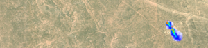
DATA.AIR brings the pinpoint accuracy of GHGSat’s proprietary satellite sensor technology to an airborne platform for localized, responsive emissions monitoring campaigns. The patented instrument, GHGSat-AV, can operate at different altitudes, trading spatial resolution for coverage to meet specific survey requirements, and accurately detects and measures methane emissions from individual sources down to 10 kg/hr.
Designed to complement GHGSat’s satellite service (DATA.SAT) and Emission Analytics, DATA.AIR is used for targeted, responsive campaigns that evaluate asset performance, safety and environmental impact – optimizing leak detection and repair (LDAR) programs through a tiered emissions data solution that combines frequent satellite revisits with detailed aerial surveys. It reduces the need for costly ground surveys by covering large geographic areas, remote facilities and multiple sites quickly, delivering detailed, localized emissions intelligence with accurate, verifiable data suitable for compliance and environmental reporting.
Documentation
No public datasheet yet — request the datasheet / ICD from the supplier.