Orbita OHS Hyperspectral Satellite
 Zhuhai Orbita Aerospace
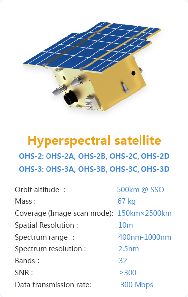
10 m-resolution hyperspectral microsatellite platform (32 bands, 2.5 nm spectral resolution) forming the OHS series of the Zhuhai-1 constellation.
Technical specifications
- Model
- OHS-2A, OHS-2B, OHS-2C, OHS-2D, OHS-3A, OHS-3B, OHS-3C, OHS-3D
- Orbit altitude
- 500 km @ SSO
- Mass
- 67 kg
- Coverage (image scan mode)
- 150 km x 2500 km
- Spatial resolution
- 10 m
- Spectrum range
- 400-1000 nm
- Spectrum resolution
- 2.5 nm
- Bands
- 32
- SNR
- ≥300
- Data transmission rate
- 300 Mbps
- Launch dates
- OHS-2 series: April 26, 2018; OHS-3 series: Sept 19, 2019
- Launch vehicle
- CZ-11
- Launch site
- Jiuquan Satellite Launch Center (JSLC)
About
The OHS is Orbita’s hyperspectral-imaging microsatellite platform, the core payload of the Zhuhai-1 constellation’s spectral-imaging capability. Each 67 kg satellite operates in a 500 km sun-synchronous orbit and captures imagery across 32 spectral bands spanning 400-1000 nm at 2.5 nm spectral resolution, with 10 m ground sampling distance and a 150 km x 2500 km image-scan swath. Two sets of four satellites (OHS-2A/B/C/D and OHS-3A/B/C/D) were launched in April 2018 and September 2019 respectively on CZ-11 rockets from Jiuquan, alongside the OVS-2/OVS-3 video satellites. OHS data is used for agriculture, forestry, water quality, ecological and environmental monitoring, and mineral/land-cover classification.
Documentation
No public datasheet yet — request the datasheet / ICD from the supplier.