Program Complex for Processing, Monitoring and Visualization of Geospatial Data
 Glavkosmos
The Software Complex consists of three modules. The Complex is designed for converting digital geodata from standard raster formats into a unified light tile format for data presentation, as well as for monitoring the results of re-conversion, on-line visualization and managing the total amount of d
About
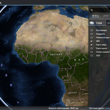
The Software Complex consists of three modules. The Complex is designed for converting digital geodata from standard raster formats into a unified light tile format for data presentation, as well as for monitoring the results of re-conversion, on-line visualization and managing the total amount of data stored in the storage device.
Documentation
No public datasheet yet — request the datasheet / ICD from the supplier.